

Table of Contents
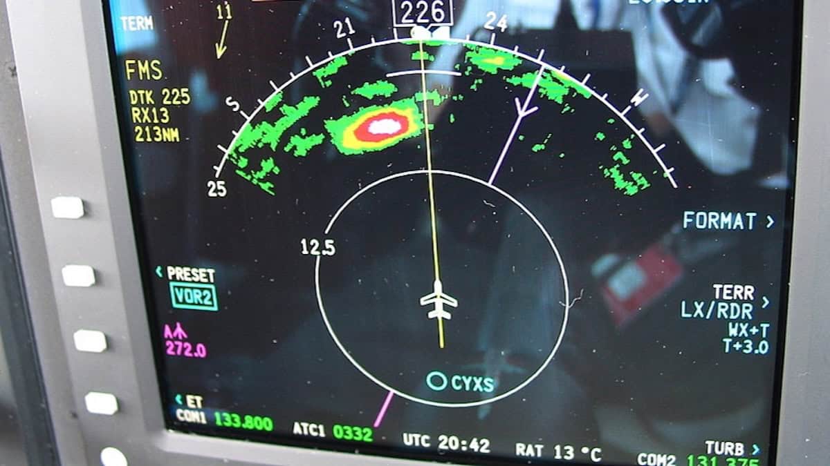
Somewhere over the Midwest on a summer evening, a pilot keys the radio and asks for “twenty right for weather.” Ahead, on the screen between the two pilots, a blob of green, yellow and red sits across the planned route.
That picture comes from a radar hidden behind the airliner’s nose cone. Most passengers assume it shows the storm clouds, but it cannot see a cloud at all.
Here is what the radar actually sees, the three places it goes blind, and how pilots, controllers and dispatchers cover for it.
How Does Airplane Weather Radar Work?
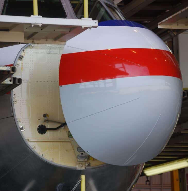
A flat antenna plate behind the nose cone sweeps from side to side, firing short pulses of radio energy ahead of the aircraft. When a pulse hits raindrops or wet hail, a sliver of the energy bounces back. The radar times each echo to work out the distance and measures its strength to judge how intense the weather is.
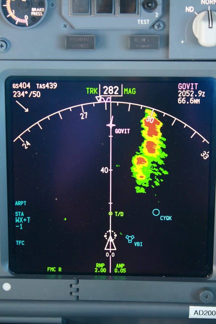
The result is painted onto the pilots’ navigation displays, the same screens described in our guide to the glass cockpit. Echoes run from green through yellow to red as they strengthen, and modern sets add magenta for turbulence.
Most airborne weather radars work at a wavelength of about 1.2 inches (3 cm), in what engineers call the X band, according to the FAA’s Aviation Weather Handbook. The National Weather Service’s ground radars use waves roughly three times longer, a difference that matters later.
For US airlines the radar is not optional. Under 14 CFR 121.357, a flight cannot be dispatched in instrument conditions or at night toward expected thunderstorms unless its weather radar works.
If the radar fails in flight, the crew follows the airline’s own procedures. In August 2026 that sent an American Airlines 737-800 back to Los Angeles after a warning light said the plane might not be able to detect hazardous weather ahead.
At a glance
Airborne weather radar sees liquid water: rain and wet hail. It does not see clouds, fog, or clear-air turbulence, and it sees ice, snow and dry hail poorly. Heavy rain can also block its view of whatever sits behind it. Pilots cover those gaps with wide avoidance margins, ground radar data from dispatch and air traffic control, and reports from other crews.
It Sees Raindrops, Not Clouds
Honeywell’s operating guide for the RDR-4B, the radar fitted to the Austrian A320 described below, puts it bluntly: “Radar detects rain drops and wet hail, not clouds, fog, snow or ice.”
The reason is drop size. According to NOAA, the power a raindrop sends back rises with its diameter to the sixth power.
Double a drop’s width and its echo grows 64 times. Triple it and the echo grows 729 times.
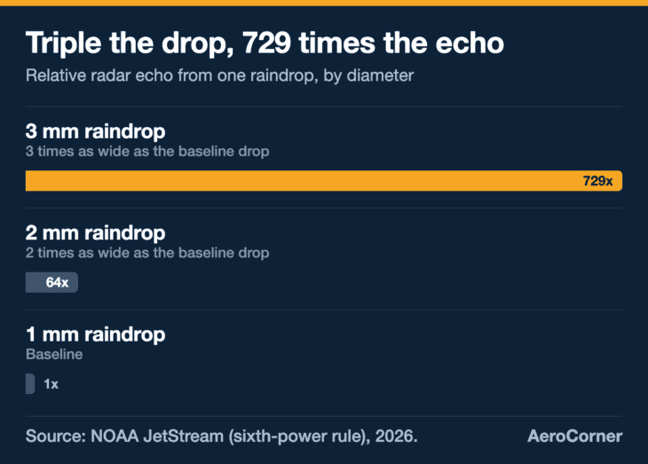
NOAA’s own example: a box holding 729 raindrops 1 millimeter (0.04 inch) across returns the same echo as a box holding a single 3-millimeter drop. Yet the rain in the first box is falling 22 times harder.
Cloud droplets are far smaller than any raindrop, so their echo is vanishingly weak. NOAA puts the raw reflectivity of tiny water droplets at around 0.001 units, against up to 36,000,000 for hail inside a severe thunderstorm.
A 36-billion-fold range
The same radar has to handle echoes from tiny water droplets and from hail in a severe thunderstorm that differ by a factor of about 36 billion, according to NOAA. That is why radar intensity is measured on a logarithmic decibel scale (dBZ) rather than in raw units.
Phase matters as much as size. Ice reflects radar energy much less well than liquid water, so the same storm looks very different depending on what state its water is in.
| Target | How well the radar sees it |
|---|---|
| Large wet hail | Excellent: it looks like a giant water drop |
| Rain | Good |
| Small dry hail | Poor |
| Ice crystals | Poor |
| Snow | Not reliably detected |
| Cloud and fog | Not detected |
So the colors are an estimate of how much liquid water is in the air, not a map of clouds and not a direct reading of turbulence. Heavy rain usually does travel with violent air, which is why the red areas get so much respect.
Why the Top of a Storm Can Vanish From the Screen
A thunderstorm is wet at the bottom and frozen at the top. Above the freezing level its water turns into ice crystals and dry hail, which, as the table shows, barely register. The highest level the radar can still detect is called the radar top, and the real cloud top can sit well above it.
That makes the angle of the antenna critical. On the A320’s radar, the pilots can tilt it up to 15 degrees above or below the horizon. Point it too high at cruise altitude and the beam slices through the weakly reflective frozen top instead of the wet core below.
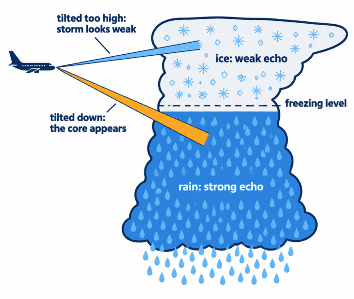
Honeywell warns that when an airliner passes over a nearby storm, the less reflective frozen top can leave the storm “appearing to decrease in intensity or even disappear from view altogether.” That is exactly when a crew needs it most.
Hence one of the FAA’s thunderstorm rules: tilt the antenna up and down occasionally. Another says any storm with tops at 35,000 feet (10,700 m) or higher should be treated as extremely hazardous, whether the top was seen by eye or by radar.
The beam is also wide. The FAA puts airborne radar beam widths at 3 to 10 degrees, and at 60 nautical miles an average 5-degree beam cannot separate two storms less than 5.5 nautical miles apart. A gap between cells often only appears on the screen as the aircraft gets closer.
Newer 3D radars take the guesswork out of tilt. Honeywell’s IntuVue RDR-4000 interweaves up to 17 scans at different angles into a volume from the ground to 60,000 feet (18,300 m), out to 320 nautical miles, and automatically compensates for how weakly ice reflects.
The Blind Spot Behind a Heavy Storm
Short radio waves are good at spotting small targets, but heavy rain soaks them up. The FAA’s handbook says that because of this attenuation, airborne radar “typically only shows the leading edge of extreme intensity echoes.”
Anything behind that leading edge may be starved of radar energy. The screen can then show a clear-looking gap, a radar shadow, where the heaviest rain or a second storm is actually sitting.
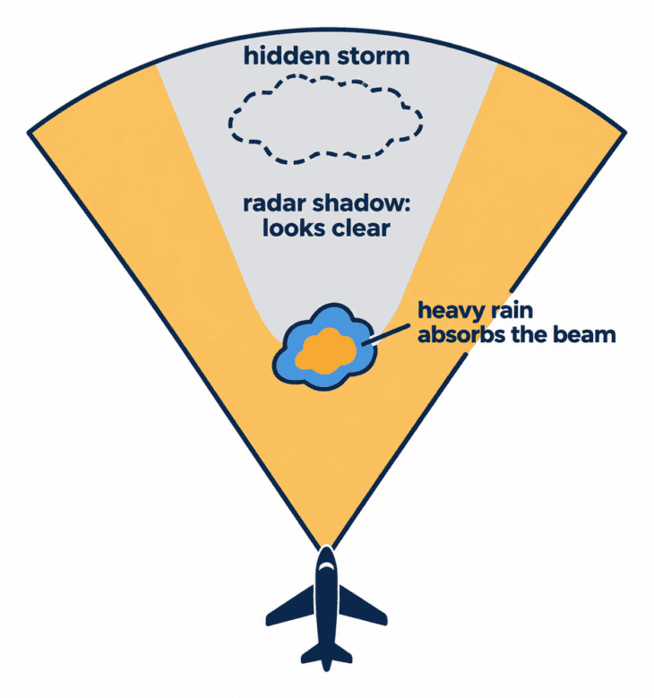
Ground radars do not have this problem to the same degree. The National Weather Service’s WSR-88D network uses a 4-inch (10 cm) wavelength that the FAA says is “not significantly attenuated by precipitation.”
Distance weakens echoes too. The FAA notes most airborne radars only compensate for range out to 50 to 75 nautical miles, so storms beyond that look weaker than they are. Some newer sets now mark the areas affected by attenuation on the display, a feature Honeywell calls REACT.
Myth: black on the screen means clear air
A black area on an airborne weather radar only means no echo came back. Behind a strong cell it may be a radar shadow, where the FAA says attenuation can keep the radar from detecting more storms. It also shows nothing about clouds, clear-air turbulence, or dry hail.
What Is Doppler Radar, and What Does It Add?
Doppler radar measures motion as well as distance. It keeps track of the phase and shape of each pulse it sends out, and when that pulse bounces off something moving toward or away from it, the returning wave comes back slightly shifted.
NOAA compares it to the Doppler shift in sound: something coming toward you sounds higher-pitched, and lower as it moves away. From that shift, the radar calculates how fast the raindrops are moving along the beam.
In smooth air, the drops in one patch of sky move together. In turbulent air they are thrown around at a jumble of different speeds, which spreads the Doppler readings out. Radar researchers at NOAA’s National Severe Storms Laboratory note that in thunderstorms this spread comes mainly from turbulence.
That spread is what an airliner’s turbulence mode paints in magenta. On the A320’s RDR-4B, turbulence shows out to 40 nautical miles, and Honeywell’s RDR-4000 can extend that to 60. The radar also scans for windshear near the runway, and Honeywell rates the RDR-4000’s predictive windshear out to 5 nautical miles.
The catch is that Doppler needs something to bounce off. The FAA is explicit that these radars detect turbulence associated with precipitation but cannot detect clear-air turbulence.
And the danger does not end where the echo ends. The FAA warns that hazardous turbulence may extend as much as 20 miles (32 km) from the echo’s edge, and that hail can fall several miles from the nearest visible cloud.
The Hailstorm an A320’s Radar Did Not Show
On June 9, 2024, Austrian Airlines flight 434, an Airbus A320 flying from Palma de Mallorca to Vienna with 173 passengers, was descending through about 20,000 feet (6,100 m) near Hartberg in southeastern Austria when it flew into a hail cell.
According to Austria’s Federal Safety Investigation Authority (SUB), both pilots said their radar was switched on and fully working, with no echoes suggesting storms or hail. After the hail began, the first officer said the screen still showed nothing.
The encounter lasted about 40 seconds. When the jet landed safely in Vienna, the outer layers of the windshields were cracked, the leading edges were dented, and the radome was almost entirely gone, taking damage to the radar antenna behind it.
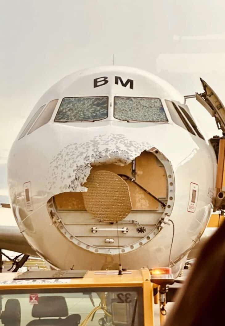
The report explains why the nose broke so easily: because the radome must be transparent to radar signals, it has only limited structural strength. The nose cone is weak on purpose.
Why the radar showed nothing is not settled. Investigators quoted Honeywell’s warning that small dry hail reflects poorly, planned a technical examination of the radar parts, and are studying whether silver iodide seeded into the cell by hail-suppression aircraft changed how reflective it was.
Austria later handed the investigation to Germany’s BFU. As of February 2026, no final report had been published.
How Pilots Fill the Gaps
The first defense is distance. FAA guidance tells pilots to avoid any storm that is severe or gives an intense radar echo by at least 20 miles (32 km), and to fly between two such echoes only if they are at least 40 miles (64 km) apart.
If storms cover more than half an area, the advice is to go around the whole thing.
Air traffic control adds a second view. En route centers display a mosaic from the ground NEXRAD network and describe intensity to pilots as light, moderate, heavy or extreme, with extreme meaning above 50 dBZ.
That picture has limits of its own. The FAA’s Aeronautical Information Manual says a center controller’s precipitation data can be up to 6 minutes old, that ATC systems cannot see clouds, and that ATC radar cannot detect turbulence.
Controllers also approve deviations only as traffic allows, because keeping aircraft apart comes first. That is why pilots ask for “twenty right” rather than simply turning.
On the ground, the airline dispatcher watches the bigger picture. Federal rules require the dispatcher to pass the captain any new information on thunderstorms, clear-air turbulence and low-altitude wind shear during the flight.
Ground radar pictures sent to a pilot’s tablet or cockpit by datalink trade freshness for range. The FAA puts their latency at 5 to 15 minutes or more and warns they show “where the weather was, not where the weather is.”
So the tools split the job. Ground radar and dispatch handle strategy, choosing routes that avoid storms entirely, while the radar in the nose handles tactics close in, with minimal delay.
The final layer is other pilots. Crews listen for aircraft ahead requesting deviations and file their own reports. When nothing gets them around the weather safely, the FAA’s advice is to divert or wait it out on the ground, and that is one reason flights divert.
Plain rain, by contrast, almost never stops a flight. The radar is not there to avoid getting wet. It is there to find the few cells that can do real damage.
Next time you see a deviation on the moving map, picture the flat antenna behind the nose, tilting up and down through a storm it can only half see. The route bends because the pilots are steering around what the radar shows, and leaving a wide margin for what it cannot.
Sources and references used for research and fact-checking.
- Federal Aviation Administration, Aviation Weather Handbook (FAA-H-8083-28B)
- Federal Aviation Administration, Aeronautical Information Manual, Chapter 7, Section 1: Meteorology
- eCFR, 14 CFR 121.357: Airborne weather radar equipment requirements
- eCFR, 14 CFR 121.601: Aircraft dispatcher information to pilot in command
- NOAA JetStream, Radar Images: Reflectivity
- NOAA JetStream, How Radar Works
- Honeywell Aerospace, IntuVue (RDR-4000) Weather Radar White Paper
- Sicherheitsuntersuchungsstelle des Bundes (Austria), Vorläufiger Untersuchungsbericht Nr. 2 (Written Preliminary Report No. 2), A320 hail encounter near Hartberg, 9 June 2024
- Austrian Wings, Causa AUA-Hagelflug: Stimmenrekorder und Datenschreiber wurden ausgelesen, nichts vertuscht
- American Meteorological Society (Melnikov, Doviak and Fang, CIMMS/NSSL), Radar Observations of Turbulence and Wind Shear
Get the Newsletter
The latest aviation news and stories sent to your inbox.
About the Author

Tim is the owner and lead editor of AeroCorner since 2019, overseeing aviation content covering aircraft, airlines, airports, and the broader aviation industry. Through years of researching, writing, editing, and publishing aviation-focused content, he has developed extensive practical knowledge of commercial aviation and air travel. Based in Asia and a frequent traveler himself, Tim also brings firsthand passenger experience to AeroCorner’s coverage. Outside of publishing, he has also explored aviation firsthand through hands-on flight training in New Zealand.