


Table of Contents
Open a flight-tracking app after a small plane goes down and you will often see the same thing. A neat line climbs away from the runway, then the dots keep going, smooth and evenly spaced, as if nothing happened.
When a Cirrus SR22 crashed near Lee C. Fine Airport at Lake of the Ozarks on November 3, 2026, its FlightAware record held exactly one position received from the airplane after takeoff. Every point after it was labeled “approximate,” as our report on the N313DG crash noted.
Those later dots were never sent by the airplane. This article explains where the real dots come from, why small planes so often drop out of view near the ground, and what a tracker is doing when it draws a position it never received.
How Do Flight Trackers See Small Planes?
Mostly by listening. A small plane with ADS-B Out works out its own position from GPS and broadcasts it about once a second, and anyone with a receiver in range can hear it. FlightAware, Flightradar24 and ADS-B Exchange collect those broadcasts from thousands of ground receivers and stitch them into a track.
Where no receiver hears the plane, the trackers fall back on other sources: timing tricks between receivers, government feeds, and finally an estimate. An estimate is a projection, not a report from the airplane.
The answer at a glance
Real positions come from the airplane’s own ADS-B broadcast, picked up by a receiver that has line of sight to it. Low, small planes are the easiest to lose, because radio needs a clear straight path. When nothing is heard, a tracker may draw estimated or approximate points. Those show where the plane might have been, never where it was.
The Airplane Reports Itself: ADS-B and the 2020 Rule
ADS-B stands for Automatic Dependent Surveillance-Broadcast. Unlike a radar transponder, which answers when a ground radar interrogates it, an ADS-B Out unit transmits on its own, sending position, altitude and velocity every second.
Since January 1, 2020, the FAA has required ADS-B Out in most of the busy airspace over the US.
Under 14 CFR 91.225, that means Class A, B and C airspace, the area within 30 nautical miles of the major airports listed in the rule up to 10,000 feet, and Class E airspace at and above 10,000 feet over the 48 contiguous states, except within 2,500 feet of the ground.
The rule has two catches that matter for small planes. It covers airspace, not aircraft, so a light plane that stays low and away from big airports can legally fly without ADS-B Out. And aircraft never certificated with an engine-driven electrical system, such as gliders, balloons and some older light planes, are exempt in much of that airspace.
An airplane that does carry ADS-B Out must leave it transmitting at all times, the rule says, unless ATC or the FAA directs otherwise. So most of the time an equipped plane is broadcasting. The question is whether anyone is close enough to hear it.
Two frequencies, two kinds of receiver
The US runs ADS-B on two links. Airliners and high-performance aircraft use 1090 MHz, which is also the only link allowed in Class A airspace above 18,000 feet. The FAA picked the 978 MHz Universal Access Transceiver, or UAT, for the typical general aviation airplane flying lower.

A receiver tuned to 1090 MHz does not hear a 978 MHz broadcast. A small plane with a UAT-only installation therefore needs a 978 MHz receiver within range before a tracking site can see it at all.
Who Is Listening: Volunteer Receivers and Line of Sight
The tracking sites do not run a national network the way the FAA does. Flightradar24 had more than 40,000 connected receivers as of 2023, most of them run by volunteers. ADS-B Exchange says it is powered by more than 25,000, and FlightAware operates its own receivers at hundreds of airports on top of the ones hobbyists feed it.
Those numbers sound like blanket coverage, but every receiver has the same limit: radio at these frequencies travels in straight lines. A receiver can only hear an airplane it could, in principle, see. The curve of the Earth, a ridge or a stand of trees puts a low plane out of view.
The standard radio-horizon rule of thumb shows how fast that bites.
Distance in miles is about 1.23 times the square root of the antenna height in feet, summed for both ends. A rooftop antenna 30 feet up can hear a plane at 10,000 feet about 130 miles (209 km) away over flat ground, but a plane 500 feet up only about 34 miles (55 km) away.
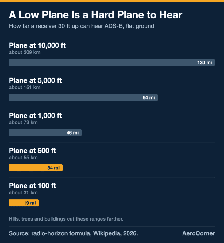
At 100 feet, the same receiver reaches only about 19 miles (31 km), and that assumes perfectly flat terrain. In hilly country the real figure can be far shorter. That is why tracks so often begin a little after takeoff and end a little before landing at small airports.
FlightAware says as much: adding receivers where coverage already exists brings “significantly better low-altitude coverage.” The airliner at 35,000 feet is heard by dozens of receivers at once. The four-seater climbing out of a rural strip may be heard by one, briefly, or by none.
When the Airplane Isn’t Broadcasting: MLAT, FAA Feeds and Estimates
A tracking site has several ways to place a plane, and they are not equally good. The table below ranks them roughly from best to worst for a small plane near the ground.
| Source | How it works | The catch for small planes |
|---|---|---|
| ADS-B | The airplane broadcasts its own GPS position every second | Needs ADS-B Out and a receiver in line of sight, on the right frequency |
| MLAT (multilateration) | Timing differences between receivers locate a 1090 MHz Mode S transponder | FlightAware needs four receivers to hear the plane, rare at low altitude; Flightradar24’s MLAT is limited in the US |
| FAA data feed | Positions from the FAA’s own surveillance, passed to tracking companies | Delayed (Flightradar24 describes a five-minute delay) and may lack details such as registration |
| Satellite ADS-B | ADS-B receivers on satellites hear aircraft far from land | Built for oceans and remote areas, not airport traffic patterns |
| Estimate | The tracker projects where the plane would be if it kept going | Not a position report at all |
MLAT is clever. Because a Mode S transponder signal reaches each receiver at a slightly different instant, the time differences reveal where it came from, even if the plane never broadcasts a position.
FlightAware says its MLAT positions arrive about 4 to 6 seconds late and work only inside a subset of its ADS-B coverage, because four receivers must hear the plane at once.
Government data fills more gaps. FlightAware says it aggregates data from more than 50 government sources, and that VFR flights, the kind most small planes fly with no flight plan, can be tracked only when “a position source such as radar or ADS-B data” is available.
A plane with no flight plan shows up as a “position-only” flight with no origin or destination.
What an “Approximate” or “Estimated” Position Really Is
When every real source goes quiet, a tracker has a choice: stop drawing the plane, or guess. FlightAware’s FAQ says it will “sometimes only have an estimate of a flight’s position,” and that such an estimate may be accurate to within a few miles or off by several hundred.
FlightAware marks this on its map. When an airborne flight leaves coverage, the icon turns hollow, a range ring appears and the word “ESTIMATED” is written beside it.
A wider circle means a less certain position, and the company has said plainly that a line drawn across a gap “reflects a lack of data and you can’t draw any conclusions from it.”
Estimates also get rewritten. FlightAware says that when the next real report arrives, it suppresses the estimated positions and draws a line from the last known position to the new one, and that delayed data can change a track after the fact. A track you look at an hour later may not be the one you saw live.
Myth: the last dot on the map is where the plane came down
Not necessarily. If the tracker is drawing estimated or approximate points, it can keep moving the plane along after the last position it actually received, and those points carry no information from the airplane. The last received ADS-B or MLAT position is the last real fact. Anything after it is a projection.
The reverse error happens too. A track can end well short of where a plane actually went, simply because it descended below the last receiver’s line of sight. An empty stretch of map is a gap in listening, not proof that the airplane stopped there.
Why Some Small Planes Don’t Show Up at All
Owners can also ask to be hidden. The FAA’s Limiting Aircraft Data Displayed program, known as LADD, lets an owner request that their aircraft be blocked from the FAA data that tracking sites display. Flightradar24 honors LADD, and on FlightAware a blocked aircraft’s tracking details are available only to its owner or operator.
LADD has a well-known weakness. ADS-B broadcasts are unencrypted, so anyone with a receiver can still hear a blocked plane. ADS-B Exchange describes itself as “displaying all aircraft broadcasts as received,” That is how public trackers can still follow jets whose owners asked to be hidden, the fight at the center of the Taylor Swift jet-tracking story.
The FAA’s answer is the Privacy ICAO Address program, or PIA, which assigns an aircraft an alternate, temporary address that is not linked to its owner in the public registry.
UAT-equipped aircraft have another option: an anonymous mode that uses a random, self-assigned address while squawking the VFR code 1200, which you can read more about in our guide to transponder squawk codes.
Why Investigators Don’t Use the Public Map
Public trackers are hobby networks stitched together, and the NTSB works from the FAA’s own data instead. The FAA runs its own ADS-B ground network, planned at 794 ground station transceivers, alongside its radar, and its data does not depend on a volunteer’s rooftop.
In its investigation of the May 12, 2021, midair collision over Centennial Airport in Colorado, the NTSB noted that ADS-B data “was provided by the Federal Aviation Administration.” It also downloaded data from the Cirrus SR22’s on-board Remote Data Module, a record stored in the airplane itself.
That is the standard to hold a public track to. It is a useful first look, often the first public evidence of which aircraft was involved, but it is unofficial, it can be revised, and it says nothing beyond its last received point.
So the next time a track from a small plane runs on in neat, even dots after a crash, check the labels. The solid points came from the airplane. The approximate ones came from software, and the answer to what happened will come from the FAA’s data and the investigators, not the map.
Sources and references used for research and fact-checking.
- eCFR (Office of the Federal Register), 14 CFR 91.225, Automatic Dependent Surveillance-Broadcast (ADS-B) Out equipment and use
- Wikipedia, Automatic Dependent Surveillance-Broadcast
- FlightAware, FlightAware FAQ
- FlightAware, FlightAware ADS-B
- FlightAware, Multilateration (MLAT) Overview
- FlightAware, Improvements to FlightAware Maps and Understanding Map Behavior
- Wikipedia, Flightradar24
- ADS-B Exchange, ADS-B Exchange
- Wikipedia, Radio horizon
- NTSB, Midair collision, Centennial Airport, Englewood, Colorado (CEN21FA215)
Get the Newsletter
The latest aviation news and stories sent to your inbox.
About the Author

Tim is the owner and lead editor of AeroCorner since 2019, overseeing aviation content covering aircraft, airlines, airports, and the broader aviation industry. Through years of researching, writing, editing, and publishing aviation-focused content, he has developed extensive practical knowledge of commercial aviation and air travel. Based in Asia and a frequent traveler himself, Tim also brings firsthand passenger experience to AeroCorner’s coverage. Outside of publishing, he has also explored aviation firsthand through hands-on flight training in New Zealand.