

Table of Contents
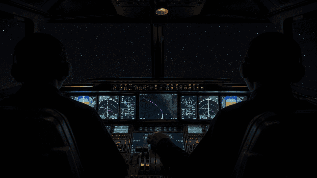
Six hours into a night crossing of the Atlantic, there is nothing outside the window. No coastline, no lights, no radar coverage, and no landmark of any kind for a thousand miles in every direction.
The aircraft will still cross the Irish coast within a mile or two of where a piece of paper said it would, at a minute or two either side of the time it predicted. It does that because a flight is not steered toward a destination. It follows a written list of named points, agreed before the aircraft ever moved.
The honest answer to how planes know where to go is not “GPS.” It is four separate layers, each one designed to keep working when the layer above it stops. Here is how each of them works, in the order they matter.
How Do Planes Know Where to Go?
Every flight begins as a route: a sequence of named waypoints and airways, filed as a flight plan and approved by air traffic control before pushback. That route is the answer to “where are we going,” and it is fixed in writing.
The answer to “where are we right now” comes from the Flight Management System, a computer that continuously calculates the aircraft’s position by blending satellite, ground-radio and motion sensors. It compares that position to the route and steers the autopilot to close the gap.
At the end, a separate system takes over for the last few miles and puts the aircraft on a specific runway centerline. Pilots monitor all of it and can fly any of it by hand.
At a glance
Navigation is four layers, not one. The route is a written list of named waypoints cleared by ATC before departure. Position comes from the Flight Management System blending GPS, ground radio beacons and self-contained inertial sensors, so no single source failing leaves the aircraft lost. Guidance is the autopilot steering along that line. The runway is found by a radio or satellite approach that works in cloud. Each layer has a fallback, which is why a GPS outage is an inconvenience rather than an emergency.
| Layer | What it does | What it relies on |
|---|---|---|
| The route | Defines where the flight goes, as an ordered list of named waypoints | A filed flight plan and an ATC clearance |
| Position | Works out where the aircraft is, continuously, to within a few hundred feet | GPS, DME ground stations, inertial sensors |
| Guidance | Steers the aircraft along the route and calculates the descent | Flight Management System, navigation database, autopilot |
| The approach | Delivers the aircraft to one specific runway, in cloud, at night | ILS radio beams or a satellite-based approach |
The Route Is Written Down Before the Wheels Move
Long before the crew reaches the aircraft, a flight plan has been built on the ground. The airline dispatcher who plans the flight picks a route through the airway network based on winds, weather, traffic and fuel cost, and files it with air traffic control.
What comes back is a clearance: the specific route the flight is permitted to fly that day. It is read to the crew, loaded into the aircraft’s computers, and cross-checked against the paperwork before the doors close. The mechanics of that exchange are covered in our guide to how a flight gets its route and why it changes.
A route is not a bearing or a heading. It is a string of fixed points, each with a published latitude and longitude, joined by published airways.
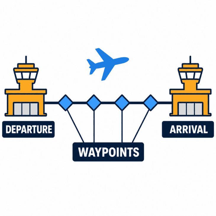
Those points are the waypoints, and they follow a global naming rule. Each one gets a unique five-letter code that has to be pronounceable over a scratchy radio and unmistakable for any other point within about 600 miles (970 km).
That constraint has produced one of aviation’s great running jokes. The people who name waypoints have to invent thousands of pronounceable five-letter words, and they have taken full advantage.
Read these five in order, out loud
An approach into Portsmouth, New Hampshire, routes aircraft over the waypoints ITAWT, ITAWA, PUDYE, TTATT and IDEED. Say them in sequence and you get Tweety Bird: “I tawt I taw a puddy tat. I did, I did taw a puddy tat.” The names are real, charted, and read out by controllers with a straight face. Elsewhere in the United States pilots fly over WONDR, MOTWN and FUBAR.
Between the waypoints run airways, the numbered corridors that keep traffic organized. Older ones are defined by ground radio beacons; newer Q and T routes exist purely as coordinates, drawn wherever the traffic flow needs them rather than wherever a transmitter happens to sit.
That shift has a name: area navigation, usually shortened to RNAV. It is the difference between following roads and being able to fly a straight line between any two points you can name.
How the Aircraft Knows Where It Is Right Now
Knowing the route is useless without knowing your own position on it. This is the part most people assume is simply GPS, and on most flights on most days, GPS is indeed doing the heavy lifting.
The constellation holds around 31 operational satellites, and a receiver needs signals from four of them to fix a position in three dimensions plus time. Accuracy is measured in feet, worldwide, at any altitude.
But an airliner does not trust one source. The Flight Management System takes several position estimates at once and merges them, weighting each by how reliable it currently is.
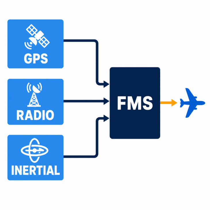
The second source is ground radio. Distance Measuring Equipment stations broadcast a signal the aircraft uses to measure its slant range from that station, and two stations at once give a position fix by simple geometry.
The third source needs nothing outside the aircraft at all. The Inertial Reference System uses laser gyroscopes and accelerometers to measure every movement the aircraft makes from the moment it is aligned at the gate.
Feed it a known starting position and it tracks the aircraft forever by pure arithmetic, with no signal of any kind. It is dead reckoning done by machine, thousands of times a second.
Its weakness is that tiny measurement errors accumulate. A typical airline unit drifts by roughly one to two nautical miles per hour of flight, which is why it is corrected constantly against the other two sources rather than used alone.
Blend all three and each one covers the others’ weaknesses. GPS is precise but comes from a faint signal sent from 12,000 miles (19,300 km) away, ground stations are robust but only exist over land, and inertial sensors are unjammable but slowly wander.
With a position and a route, the rest is arithmetic. The FMS draws the planned track on the navigation display, works out the wind, and commands the autopilot to fly it.
It also computes the descent backwards from the destination. Given the altitude restrictions on the arrival, it calculates the exact point at which the aircraft must stop cruising, which is why the descent often begins over a hundred miles out with no obvious prompt.
Over the Ocean, Nobody Is Watching on Radar
Radar needs a ground station, and there are no ground stations in the middle of the Atlantic. For most of aviation history, oceanic airspace was run on trust and arithmetic instead.
Under that system, controllers separated aircraft by time rather than by what they could see. Crews reported their position at fixed points, and the next aircraft was kept minutes behind, which meant enormous gaps and very few route options. Our guide to flying over the ocean with no radar covers the procedure in full.
That changed in 2019. A constellation of 66 Iridium satellites began carrying ADS-B receivers, so aircraft that already broadcast their own GPS position could be tracked from orbit anywhere on Earth.
The effect was immediate. Longitudinal separation over the North Atlantic dropped from about 40 nautical miles to as little as 14, and far more flights could be given the track and altitude they actually wanted.
The North Atlantic routes themselves are redrawn twice a day, chasing the jet stream eastbound and dodging it westbound. That is why the trip home takes longer than the trip out, and why the ocean crossing is never quite the same line twice.
How Did Pilots Know Where to Go Before GPS?
Every layer above replaced something older, and the older systems are mostly still there. The progression is worth knowing, because it explains why a modern cockpit still carries equipment designed in the 1940s.
1923
Bonfires, then light bulbs. Congress funded a lighted transcontinental airway, with rotating beacons roughly every 10 miles from New York to San Francisco. Airmail pilots flew at night by following a chain of lights across the continent.
1929
Flying the beams. The four-course low-frequency radio range transmitted Morse code A and N signals into four quadrants. Fly the correct path and the two merged into a steady tone, which meant a pilot could hold a course inside cloud for the first time.
1946
VOR arrives. Eight radio-range stations on the New York to Chicago airway were converted to the new VHF omnidirectional range, and general installation followed from 1947. VOR gave a precise bearing to or from a station and became the backbone of the airway system for 50 years.
1970
Navigation cuts the cord. Pan Am’s new Boeing 747s carried three inertial navigation units that needed no ground signal at all. For the first time an airliner could cross an ocean without a navigator and without listening to anything.
1995
GPS goes fully operational. A satellite fix became available worldwide, at any altitude, for the price of a receiver. Within a generation it displaced almost everything before it as the primary means of navigation.
Two of those older systems are still fitted to airliners today. The automatic direction finder still points at low-frequency beacons, and VOR stations still define much of the airway structure.
They are no longer the primary means of navigation. They are the backup, and that distinction turns out to matter more in 2026 than anyone expected 10 years ago.
The Last Few Miles: Finding a Runway You Cannot See
Everything so far gets the aircraft to the right city. Landing needs something far more precise: a specific strip of concrete, aligned to within a few feet, on a night when the crew cannot see the ground until seconds before touchdown.
The classic solution is the Instrument Landing System. Two transmitters at the airport project narrow radio beams: the localizer gives left and right alignment with the runway centerline, and the glideslope gives the correct descent angle, normally 3 degrees.
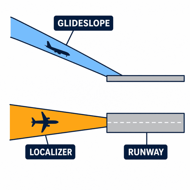
How far down that guidance is trusted depends on the equipment on the ground, on the aircraft, and on the crew’s training. A Category I approach is flown to a decision height of around 200 feet, where the crew must see the runway or go around.
Category III goes considerably further. In its lower forms there is no decision height at all, and an aircraft can be landed with a runway visual range as low as about 165 feet (50 m), which is roughly the length of the aircraft doing the landing.
At that point the autopilot flies the landing and the crew monitors it. The pilots may genuinely not see the ground until the wheels are on it.
Satellite navigation has quietly taken over the rest. Thousands of runways that will never justify the cost of an ILS installation now have published GPS approaches with vertical guidance, which is how small airports acquired all-weather access without a single new transmitter.
None of this replaces looking outside. It buys the crew the last few hundred feet, at which point approach lighting takes over and the landing becomes visual, a handover explained in our piece on how pilots see at night.
What Happens When the GPS Signal Lies
All of the above assumes the satellite signal is honest. Increasingly, in several parts of the world, it is not.
There are two separate problems. Jamming drowns the satellite signal in noise so the receiver simply loses its fix, which is obvious and annoying. Spoofing broadcasts a convincing fake signal, so the receiver confidently reports a position that is wrong, which is far worse.
The scale grew fast. An industry working group tracked interference rising from around 300 affected flights a day in early 2024 to roughly 1,500 a day by that August, concentrated near conflict zones.
European regulators now treat it as a standing hazard rather than an anomaly. EASA’s bulletin on satellite navigation outages reached its fourth revision in July 2026, naming the Baltic, eastern Europe, the Mediterranean, the Black Sea and the Middle East as the worst-affected regions.
The symptoms it lists are strange ones. Crews see the position jump, ground speed disagree with airspeed, the aircraft clock shift by hours or days, and terrain warnings fire over flat open water.
The myth: lose GPS and the aircraft is lost
This is the assumption behind most alarming headlines about spoofing, and it is wrong. GPS is the most convenient position source on an airliner, not the only one. Switch it off and the inertial platform keeps running untouched, ground stations keep transmitting, and the crew can navigate beacon to beacon exactly as airliners did until the 1990s. The genuine hazards of spoofing are the secondary ones: false warnings, corrupted timing, and the workload of sorting out which instrument is lying.
Regulators have gone further than simply warning about it. In the United States, the entire ground beacon network is being deliberately preserved for this scenario.
The FAA’s VOR Minimum Operational Network keeps a thinned but strategically chosen set of stations alive purely as a GPS backup. Coverage is guaranteed from 5,000 feet above ground level, and the network is built so that an aircraft anywhere in the contiguous United States is within 100 nautical miles of an airport with an approach that needs no GPS at all.
The pruning is real: as of mid-2025 the FAA had discontinued 200 of the 302 stations marked for removal. What survives is not a leftover. It is a maintained fallback, kept running for a day nobody expects.
That is the actual design philosophy of aircraft navigation, and it is the opposite of how most people imagine it. Nothing is trusted on its own.
So the next time a flight map shows your aircraft as a small icon crawling across an empty ocean, the interesting part is not that it knows where it is. It is that it knows in four different ways at once, and is quietly checking each one against the others.
The route was written before you boarded. Everything since has been the aircraft proving, several times a second, that it is still on it.
Sources and references used for research and fact-checking.
- Federal Aviation Administration, Very High Frequency Omnidirectional Range Minimum Operational Network (VOR MON)
- Federal Aviation Administration, Backup Navigation During a GPS Disruption: VOR MON and NextGen DME Programs (22 July 2025)
- European Union Aviation Safety Agency, EASA updates Safety Information Bulletin on GNSS interference
- OPSGROUP, GPS Spoofing: Final Report published by WorkGroup
- NAV CANADA, Space-based ADS-B surveillance improves trips over the North Atlantic
- AeroSavvy, Air Navigation Name Nonsense
Get the Newsletter
The latest aviation news and stories sent to your inbox.
About the Author

Articles credited to the AeroCorner Editorial Team are created or maintained by multiple aviation contributors working under a shared editorial framework. Content is researched using authoritative aviation sources and reviewed to ensure clarity, technical accuracy, and consistency across AeroCorner.