

Table of Contents
On November 1, 2026, a Learjet 60 was flying over South Florida at about 35,000 feet when its pilot gave Miami Center a weather report. According to CNN’s account of the LiveATC recording, the pilot said, “We have light, clear ice that is manageable and moderate turbulence,” and gave the outside air temperature as -47°C (-53°F).
Minutes later the crew declared a mayday, and the jet came down near Greenacres, killing all nine people aboard. The NTSB has not determined a cause, and nothing in this article is an explanation of the N722BD crash, which we are covering separately.
The radio call does raise a question many listeners asked: how can anything ice up at -47°C, in air colder than -50°F? The answer involves water that refuses to freeze, ice that refuses to stick, and a hazard the industry only wrote certification rules for in 2014.
Can Planes Ice Up at High Altitude?
Yes, but usually not in the way people picture. The classic icing that coats a wing needs liquid water droplets colder than freezing, and in real clouds those droplets disappear at roughly -38°C to -40°C (about -36°F to -40°F). Colder than that, the cloud is almost entirely ice crystals.
Ice crystals bounce off a cold wing. What they can do is build up on the few surfaces of an airliner that are warm: inside the engine core, and in the heated probes that measure airspeed. That is high-altitude ice crystal icing, and it has caused more than a hundred engine power losses.
The answer at a glance
Liquid cloud water has been measured down to -37.5°C and freezes on its own just below that, so ordinary airframe icing runs out near -40°C. Above deep thunderstorms, dense clouds of ice crystals take over. They do not stick to cold metal, but they can melt, stick and freeze on warm engine parts and heated airspeed probes.
Water That Stays Liquid Far Below Freezing
Water in a cloud does not freeze at 0°C (32°F). Tiny droplets need a speck of dust or another particle to start the crystal, and high in the atmosphere those specks are scarce, so droplets stay liquid well below freezing.
Pilots call this supercooled water, and it is the raw material of the rime, clear and mixed ice that forms on wings.
There is a floor. In a 2000 paper in Nature, researchers Daniel Rosenfeld and William Woodley flew an aircraft into deep convective clouds and found most of the condensed water still liquid at -37.5°C (-35.5°F). At slightly colder temperatures they found only ice.
The same paper notes that a typical 10-micron cloud droplet freezes on its own, with no particle needed, near -39°C. Physicists call that homogeneous freezing. By -47°C, a cloud should hold essentially no liquid water at all.
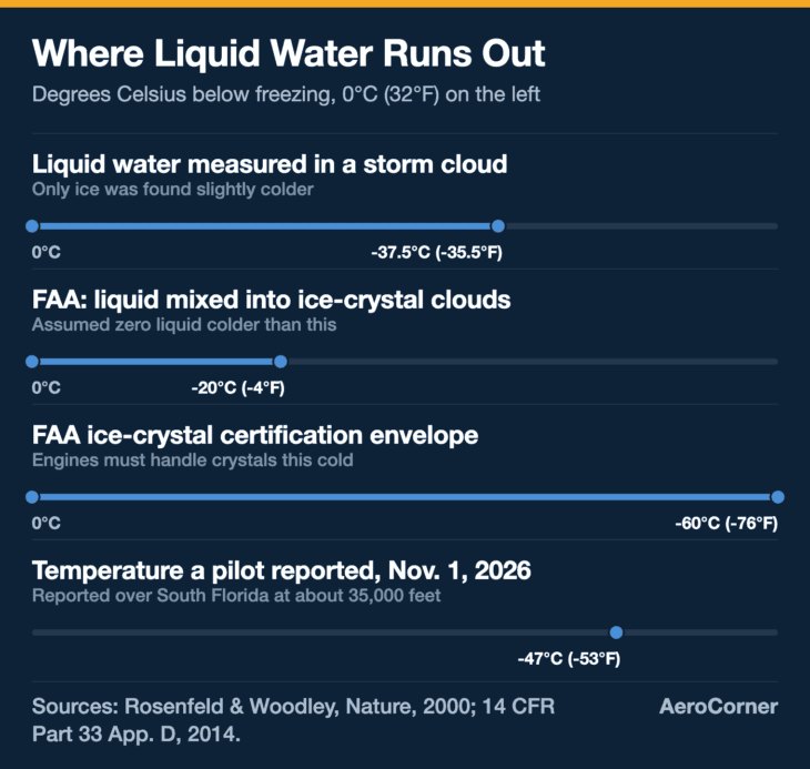
The FAA builds that physics into its rules. Its certification envelope for ice crystal clouds assumes some supercooled liquid mixed in between 0°C and -20°C (-4°F), and none at all colder than -20°C.
The Ice That Doesn’t Stick to the Wing
If liquid water runs out, the ice does not. A big thunderstorm pumps enormous amounts of moisture to the top of the troposphere, where it freezes into crystals and spreads downwind from the storm tops. These crystals are tiny: the FAA’s design standard puts their median size at 50 to 200 microns.
A frozen crystal hitting a frozen wing just bounces off. In the FAA’s own words, ice crystal icing “does not affect cold airframe surfaces, only some heated engine surfaces.” That is why the airplane’s ice detector, which looks for ice building up on a probe, does not detect ice crystals either.
Weather radar struggles too. SKYbrary, the aviation safety reference, puts the radar reflectivity of these crystals at about 5% of average raindrops, so a cloud packed with them can look benign on the cockpit display.
What crews do notice is strange. The FAA’s research summary says engine events typically happen within 30 nautical miles of convective weather, in mild or moderate turbulence, and are often “reported as rain on windshield at very high altitudes where liquid precipitation is not possible.” The likely explanation is crystals melting on the heated windscreen.
Denser than any icing cloud engines were built for
SKYbrary notes that localized pockets near storms can hold about 8 grams of ice per cubic meter of air, four times the 2 grams per cubic meter of supercooled liquid water used as the engine design standard.
Inside the Engine: Ice That Grows on Warm Metal
The engine is where this hazard bites. Air entering the core is squeezed and heated by the compressor, so the metal inside is far warmer than the outside air. The FAA’s engine icing advisor laid out the sequence at a 2015 science forum.
Frozen crystals strike warm surfaces inside the compressor, and some of them melt. Crystals that hit the wet surface stick, cool it to 0°C, and then ice begins to form. At high altitude, that ice can grow deep inside the engine core, in places the engine’s anti-ice system was never designed to protect.
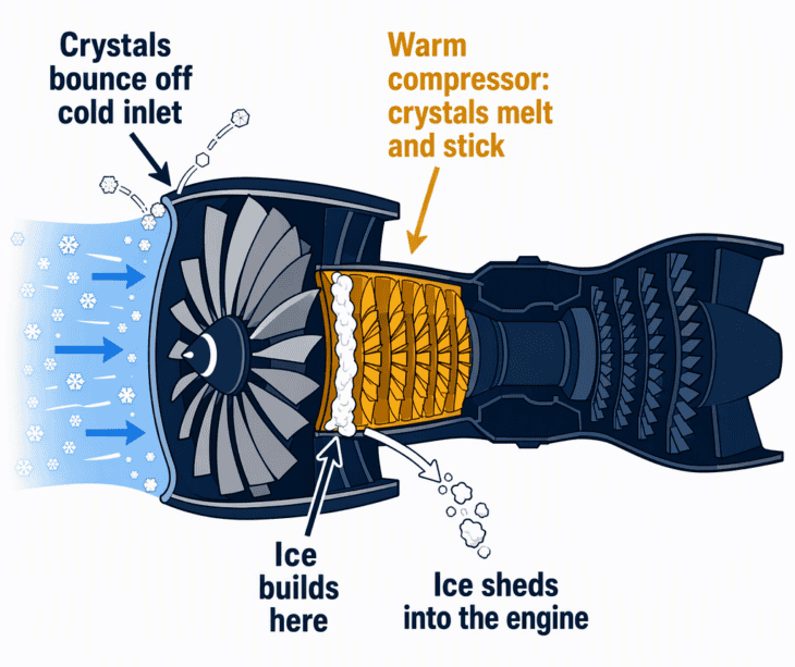
When that ice breaks loose, the engine swallows it. SKYbrary describes the result as an uncommanded loss of thrust, with rpm falling and exhaust temperature rising, a “rollback” that can continue below idle. The FAA also counts surges, stalls and flameouts as power-loss events, and some encounters damage the engine.
This is not rare. The FAA counted 148 engine power-loss events tied to ice crystals in airline service: 97 found in a review of 1988 to 2003, and 51 more identified by 2012. A Boeing map from around 2009 put 57% of them in the Pacific-Asia region, which the FAA linked to the region’s high sea surface temperatures.
SKYbrary notes most events happened early in a descent from high altitude, with the engines at flight idle, and recommends a thrust setting above idle when descending through tropical convective areas.
Pitot Probes and Air France 447
The other warm spots on an airliner are its pitot probes, the small heated tubes that measure airspeed. A dense enough stream of crystals can block them anyway, and the airspeed readings go wrong.
That is the first link in the chain the French investigator BEA laid out for Air France Flight 447, the Airbus A330-200 lost over the Atlantic on June 1, 2009, with all 228 aboard.
The BEA’s final report starts with “the obstruction of the Pitot probes by ice crystals” and a temporary inconsistency between the measured speeds, which disconnected the autopilot.
The ice did not bring the jet down on its own. The BEA’s next links are the crew’s control inputs, the missing connection to the unreliable-airspeed procedure, and a stall that went unrecognized. AF447 is the textbook case because it shows how a temporary sensor fault can start a much worse chain.
Ice crystal icing does not cause crashes by itself
Every source here describes ice crystals as the start of a problem: a power rollback, a lost airspeed reading, an autopilot that drops out. Whether a flight survives depends on what happens next, which is why investigators take months, not minutes, to name a cause.
What Changed After 2009
For decades, icing certification only covered clouds of supercooled droplets. The push to widen it began after the 1994 American Eagle crash at Roselawn, Indiana, and an engine working group set up for the FAA then found a second hazard in the event history: high-altitude convective weather where the water is frozen.
The result was a final rule published on November 4, 2014, effective January 5, 2015.
It added Appendix D to Part 33, a “Mixed Phase and Ice Crystal Icing Envelope (Deep Convective Clouds)” that engines must now be shown to handle. It also requires airspeed systems on transport airplanes to have a heated pitot tube or equivalent that prevents malfunction in those same ice crystal conditions.
The catch is age. The FAA said plainly that the new rules do not apply to existing airplanes, because changing the certification basis of jets already flying is normally done through airworthiness directives instead. Plenty of aircraft certified before 2015 are still in service under their original standards.
Research continues alongside the rules. The FAA, NASA, Boeing, Airbus, the European Commission’s HAIC project and weather agencies in Canada and Australia have flown research aircraft through ice crystal clouds to measure them and to set design goals for cockpit radar that can spot them.
The Myth: “It’s Too Cold Up There to Ice”
The common belief is half right. It is too cold at cruise altitude for the wing-coating ice most people imagine, which is why de-icing on the ground and icing in climb and descent get most of the attention.
But “too cold for liquid water” is not “too cold for ice.” The coldest, highest clouds above thunderstorms carry the densest ice of all, and the hazard shows up in the airplane’s warmest places rather than its coldest.
The second myth is that radar or the ice detector will flag it. Neither reliably does, which is why the standard advice is to keep well clear of storm cells, with SKYbrary citing 50 nautical miles for susceptible engine types. Storm cells bring their own turbulence hazards as well.
So a pilot reporting ice at -47°C is not describing something impossible. What the N722BD crew saw, and whether it mattered, is for the NTSB to establish from the recorders, the wreckage and the weather data.
Next time you look out at a cruise-altitude sky that seems far too cold for ice, you will know the real story: the wing is safe from it, and the engines and probes are the parts doing the work.
Sources and references used for research and fact-checking.
- Cornell Law School Legal Information Institute (eCFR), 14 CFR Appendix D to Part 33: Mixed Phase and Ice Crystal Icing Envelope (Deep Convective Clouds)
- Federal Register via Justia, Airplane and Engine Certification Requirements in Supercooled Large Drop, Mixed Phase, and Ice Crystal Icing Conditions (Final Rule, 79 FR 65507)
- FAA, Tom Bond, Aircraft Icing Technical Advisor, Ice Crystal Icing Rulemaking (HAIC-HIWC Science Forum presentation)
- SKYbrary, High Level Ice Crystal Icing: Effects on Engines
- Nature (Rosenfeld and Woodley, 2000), Deep convective clouds with sustained supercooled liquid water down to -37.5 C
- BEA, Final Report presentation: Accident on 1st June 2009 to the Airbus A330-203, flight AF 447
- AVweb, Air France Flight 447 Final Report
- CBS12, Weather could have played a role in Greenacres plane crash, aviation expert says
Get the Newsletter
The latest aviation news and stories sent to your inbox.
About the Author
Tim is the owner and lead editor of AeroCorner since 2019, overseeing aviation content covering aircraft, airlines, airports, and the broader aviation industry. Through years of researching, writing, editing, and publishing aviation-focused content, he has developed extensive practical knowledge of commercial aviation and air travel. Based in Asia and a frequent traveler himself, Tim also brings firsthand passenger experience to AeroCorner’s coverage. Outside of publishing, he has also explored aviation firsthand through hands-on flight training in New Zealand.