

Table of Contents
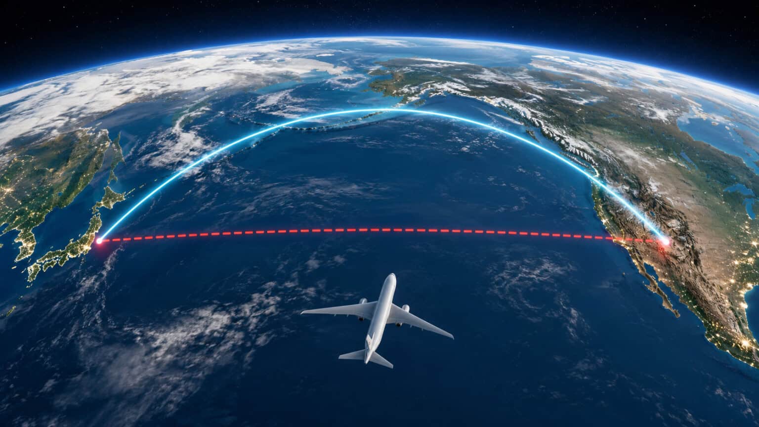
You settle into your seat for a flight from Los Angeles to Tokyo, open the moving map on the seatback screen, and watch the little airplane do something strange. Instead of heading due west across the open Pacific, it climbs north. It tracks up past San Francisco, brushes the coast of Alaska and the Aleutian Islands, then curves back down toward Japan.
It looks like a detour. A big one. Why would an airline burn extra fuel dragging a full 787 hundreds of miles out of the way toward the Arctic when Tokyo is clearly just to the west?
Here is the twist: it is not a detour at all. That curving northern arc is the shortest path there is. The straight line you are picturing is the illusion, and the reason comes down to the fact that the Earth is a ball and your map is flat. This article explains the geometry, the two other forces that fine-tune the route, and the myth almost everyone believes about it.
The short answer
The shortest distance between two points on a globe is called a great circle route, and on long east-west trips at high latitudes it bends toward the nearest pole. A flat map cannot show that honestly, so it draws the true shortest path as a curve and draws the longer path as a straight line.
Two more things nudge the exact track: the winds up at cruise altitude, and a safety rule that keeps twin-engine jets within reach of an emergency landing spot. Together they explain why nearly every North Pacific flight hugs that northern arc.
The answer at a glance
The curving northern route is the shortest one. On a round Earth, the shortest path between two far-apart cities is a great circle, which bends toward the pole. Flat maps distort that path into a curve, and distort the longer route into a deceptively straight line. Winds and diversion-airport rules fine-tune the exact track.
The real problem is your map, not the plane
Almost every world map you have ever seen uses a version of the Mercator projection. It takes the round surface of the Earth and peels it flat into a neat rectangle. That is convenient, but it comes at a cost: the further you get from the equator, the more the map stretches everything sideways.
This is why Greenland looks as big as Africa on a classroom map, when Africa is actually about 14 times larger. The distortion near the top and bottom of the map is enormous. And that same stretching is what warps flight paths.
On a globe, take a piece of string and pull it tight between Los Angeles and Tokyo. The string naturally rides up over the northern Pacific near the Aleutians. That taut string is the great circle, the genuine shortest route. Now flatten the globe into a Mercator map and that same string gets dragged into a curve arcing north, even though on the real Earth it never bent at all.
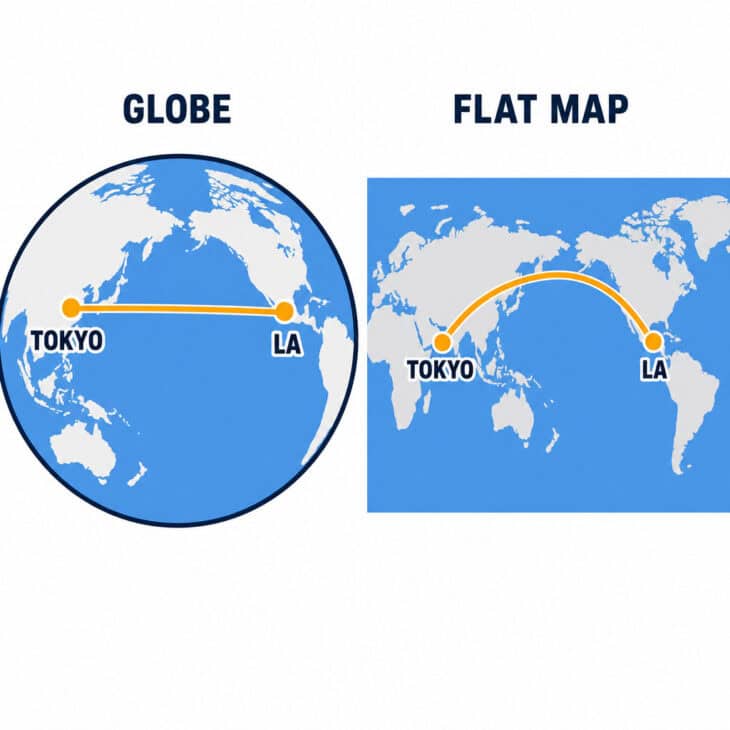
The line that looks straight on the flat map, running due west across the middle of the ocean, is actually the longer way around. It is called a rhumb line, a path of constant compass heading. It is easy to steer and it looks tidy, but on a sphere it quietly adds miles.
Why the shortest path bends toward the pole
Here is the part that breaks most people’s intuition. Los Angeles and Tokyo sit at almost the same latitude, both around 35 degrees north. So surely the shortest path is to fly straight west along that line of latitude?
No. Lines of latitude are not straight lines on a globe, they are circles, and every one except the equator is a small circle that curves the long way around. Cutting the corner by heading toward the pole and coming back down covers less ground. The higher the latitude of the two cities, the more dramatic the shortcut.
The numbers make it concrete. The great circle from Los Angeles to Tokyo runs roughly 5,450 miles (8,770 km). Following the flat-map “straight” line along the latitude line instead would add several hundred miles, close to an extra hour in the air. Multiply that by two flights a day, every day, and the fuel savings are enormous.
| Route (one way) | Great circle route | What the flat map suggests |
|---|---|---|
| Los Angeles to Tokyo | Arcs north past the Aleutians | Straight west across mid-Pacific |
| San Francisco to Seoul | Arcs north near Kamchatka | Straight west across mid-Pacific |
| New York to Hong Kong | Crosses near the North Pole | Southwest across the U.S. and Pacific |
This is the same geometry that sends flights over Canada, Greenland, and the Arctic, and it is why a flight crossing near the North Pole can be the sensible choice between two cities that are nowhere near it. The map hides the logic; the globe reveals it.
The safety rule that pulls routes north
Geometry explains the basic shape of the route, but it is not the only force at work. Most airliners crossing the Pacific today have only two engines, and two-engine jets over open ocean are governed by a rule called ETOPS.
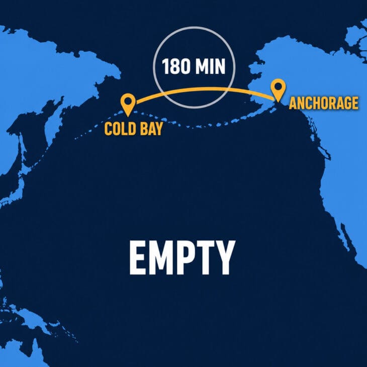
ETOPS stands for Extended-range Twin-engine Operational Performance Standards. In plain terms, it says a twinjet must always stay within a set flying time of a suitable airport where it could land if one engine failed. An ETOPS-180 rating means the plane can never be more than 180 minutes, on one engine, from a diversion airport.
Look at where the airports are. The northern Pacific is ringed with them: Anchorage, Cold Bay, and the remote strip at Shemya out on the Aleutian chain, plus fields on the Russian side. The empty middle of the ocean has almost nothing. Hugging the northern arc keeps a diversion airport within reach for far more of the crossing, so the ETOPS-friendly route and the geometrically shortest route point the same way.
Modern aircraft have stretched these limits dramatically. The Boeing 787 is certified for ETOPS-330, and the Airbus A350 carries approval as high as ETOPS-370, meaning more than six hours from an alternate. That freedom is exactly what lets airlines fly the truly remote routes, such as the world’s longest nonstop flights, across oceans that were once off-limits to twinjets.
Engines Turn Or Passengers Swim
Pilots have a grim old joke that ETOPS really stands for Engines Turn Or Passengers Swim. It is dark humor about a serious rule: on the emptiest ocean crossings, staying within diversion range of an airport is the difference between a safe landing and a very bad day. Modern twinjets like the A350 are now cleared to fly up to 370 minutes from the nearest alternate.
The winds move the line around every day
If you compare the same route on two different days, the track is never quite identical. That is the third factor: the powerful high-altitude winds that snake across the Pacific, including the jet stream.
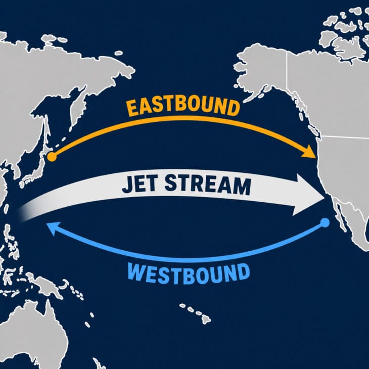
These winds routinely blow at 100 mph (160 km/h) or more, and they almost always flow west to east. A flight heading east toward North America will slide its route to ride that tailwind and arrive early. A flight heading west toward Asia will shift to dodge the worst of the headwind that would otherwise slow it down and burn extra fuel.
The result is that the eastbound and westbound tracks often differ by hundreds of miles, exactly the same effect that makes transatlantic flights take a different route each way. Dispatchers redraw the optimal path daily, wrapping the wind-tuned route loosely around the great circle rather than following it to the letter.
The myth: airlines are avoiding the deep ocean
The most common explanation you will hear is that pilots steer north out of caution, to stay near land and avoid the terrifying emptiness of the open Pacific. It sounds reasonable, and it is mostly wrong.
The misconception
Planes do not curve north because crews are scared of deep water or trying to shadow the coastline. The northern arc is chosen first and foremost because it is genuinely the shortest distance on a round planet. If the great circle happened to run straight across the middle of the ocean, that is where the flights would go, and on many routes closer to the equator they do.
Safety, in the form of ETOPS diversion airports, does reinforce the northern route on many Pacific crossings. But it is a supporting reason, not the headline. Strip away the winds and the diversion rules entirely, put the flight in perfectly still air with airports everywhere, and it would still arc north, because that is simply the shorter way from one high-latitude city to another.
It is the same principle behind why flights bend around other parts of the globe rather than bulldozing through in a “straight” line, whether that is the polar routes or the paths that steer clear of the Himalayas. The straight line on the wall map is almost never the real shortcut.
So the next time you are somewhere over the Pacific and the map shows your plane creeping toward Alaska, you can relax. Nobody made a wrong turn, and nobody is padding the fuel bill.
You are on the shortest possible line between where you started and where you are going. It only looks like a detour because the map in front of you had to lie about the shape of the world to fit it on a screen.
Sources and references used for research and fact-checking.
- Encyclopaedia Britannica, Great-circle distance
- Encyclopaedia Britannica, Mercator projection
- U.S. Federal Aviation Administration, ETOPS: Extended Operations of Multi-Engine Airplanes
- NATS (UK air navigation service provider), The North Atlantic Tracks and jet stream routing
- Karl L. Swartz, Great Circle Mapper
Get the Newsletter
The latest aviation news and stories sent to your inbox.
About the Author

Tim is the owner and lead editor of AeroCorner since 2019, overseeing aviation content covering aircraft, airlines, airports, and the broader aviation industry. Through years of researching, writing, editing, and publishing aviation-focused content, he has developed extensive practical knowledge of commercial aviation and air travel. Based in Asia and a frequent traveler himself, Tim also brings firsthand passenger experience to AeroCorner’s coverage. Outside of publishing, he has also explored aviation firsthand through hands-on flight training in New Zealand.