
Ever consider becoming a pilot? Well if so, there are numerous types of altitudes as a pilot one would have to be aware of to ensure the safety of the flight. It’s almost the same as being a pastry chef specifically because they are like chemists. They need to follow instructions. Measuring altitude in a plane consists of using different methods. MSL is one of them.
So what exactly is MSL in aviation? MSL stands for “Mean Sea Level.” Height elevation levels can be measured on one or more of the bodies of water on earth. There are also many factors that can affect sea levels. These factors vary substantially depending on different time scales.
MSL In Aviation
MSL refers to mean sea level. During different times of the flight, pilots use MSL. MSL is highly important for pilots to be able to fly steady and land safely. MSL allows pilots to measure their altitude above the ocean and seas. MSL is used as a guide by pilots for elevation.
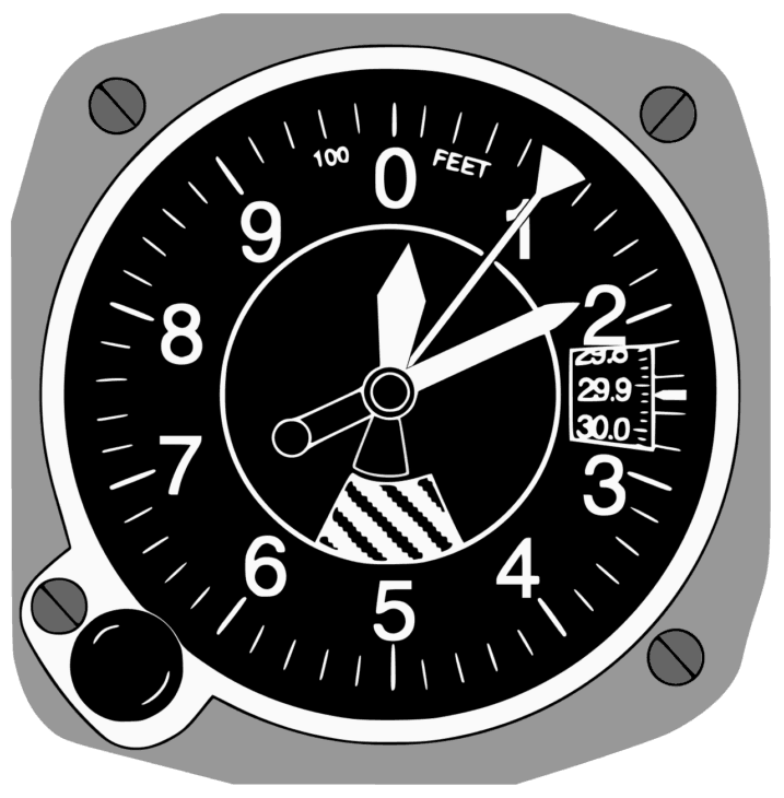
AGL, on the other hand, estimates the height above the ground. MSL and AGL operate together and serve as a pilot functioning point. The AGL is measured using altimeters. This is done when the aircraft is flying at lower heights such as when they are landing at an airport.
The altimeter will become less correct as the plane increases altitude. The plane will then use MSL once it reaches transition altitude. They use this to control the flight levels.
How is MSL Calculated?
It is really not easy to obtain an exact measurement of MSL because there are many factors that affect the level of the sea. Sea level continuously changes on a variety of scales.
This is because the sea constantly moves depending on the tides and wind. For a period of about 19 years, the MSL has been continuously measured using the rise and fall of the ocean on the seacoasts.
The atmospheric pressure and temperature also play a role in the continuous motion of the sea and being able to measure its level. A datum is the easiest way to calculate the MSL. Pilots can do this by choosing a certain location and measure the level of the sea at that certain point.
SWL or still water level are sea levels that consist of wind-wave calculations as well. MSL measurements also involve SWL when changes are relevant such as tides, etc. MSL’s values can be calculated in accordance with the land. Changes in sea level can affect the calculations of MSL.
Pilots can also estimate height levels above the ground by doing some calculations. They can easily subtract the altimeter reading from the terrain altitude since the terrain altitude is a part of MSL.
Aviation charts contain boxes in which are divided and consist of terrain altitude maximum from MSL. They are laid out in each box clearly for pilots to read. The altimeter is then set to the international standard atmosphere once the plane is above the transition altitude.
Besides pilots, sailors, astronauts, and even solders use a variety of different techniques and equipment to calculate and measure heights. There is no accuracy in height between all techniques used because there are different assumptions being made.
If a pilot tends to have the wrong height information, terrible consequences may await them. Wrong assumptions and incorrect calculations can be entirely confusing.
There is built-in flexible software in most standard GPS receivers that can meet different applications. However, these different applications need accurate elevations or heights in accordance with different zero surfaces.
The Difference Between MSL and AGL
As mentioned briefly, AGL is also known as above ground level. It measures the exact height above the ground in which a pilot is flying. MSL or mean sea level is the exact elevation or altitude.
The atmospheric pressure is measured during the height of the sea level. The calculations from the atmospheric pressure are used to determine the altitude.

If one were to look at a sectional chart, they will notice that all numbers used to indicate altitudes are indicated in MSL. This does not imply if they are indicated in parentheses. Any number that is noted in parentheses indicates AGL.
One thing to note is that it is not always possible to fly AGL since the height will consistently change once the plane once is above ground level. This is because there is an uneven ground below. Standard procedure has always been for pilots to switch over to MSL once they reach a certain altitude.
Changes in Sea Level
There are many short term and regular changes that can take place at sea. Factors that affect short term changes in sea level can be mountain glaciers and even polar ice sheets. This can result in more water going into the ocean. The water will expand as the temperature of the ocean rises.
Diurnal and semidiurnal astronomical tides are just a couple of things that can affect periodic sea-level changes. Rotational variations and long-period tides are a couple of others.
Sea levels have been rising for the past 100 years of about 1.88mm each year. Most of these rises are due to a temperature increase of the sea. The thermal expansion also plays a role in the rise of sea levels. Additionally, melting snow and glaciers contribute as well.
Accuracy of MSL
Sea level is not an easy surface. You might expect the ocean to form an even and smooth surface around the Earth since the earth has an ellipsoidal shape. However, it does not. MSL has tiny hills and valleys within it since the surface of the sea matches that gravity field.
Sea level may actually be further or closer to the center of the Earth depending on where you are. This is why vertical datums that are locally defined are different from one another.
Zero elevations that are defined by China are not the same as the zero elevations defined by Chile. Since there is no way to measure the geoid precisely, is has been approximated in the past by MSL.
Due to other ocean effects, the geoid is different from MSL by a few meters.
About the Author
Articles credited to the AeroCorner Editorial Team are created or maintained by multiple aviation contributors working under a shared editorial framework. Content is researched using authoritative aviation sources and reviewed to ensure clarity, technical accuracy, and consistency across AeroCorner.