

Table of Contents
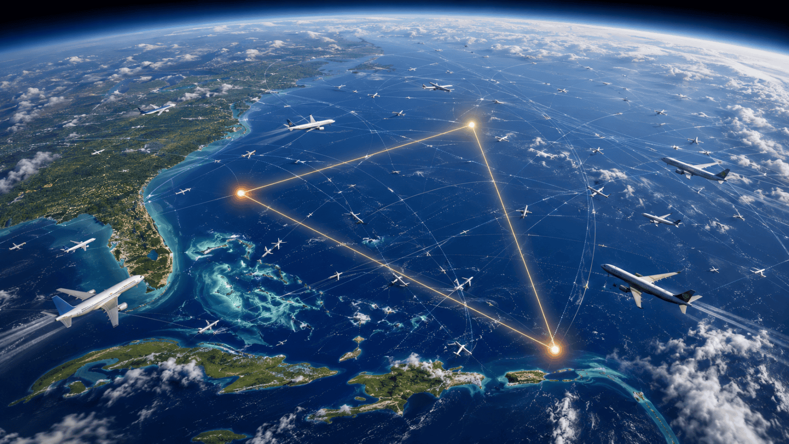
Open a live flight tracker and look at the water between Miami, Bermuda, and San Juan. It is not empty. At almost any hour, dozens of airliners are crossing it, full of people who have no idea they are inside the world’s most famous no-go zone.
The Bermuda Triangle has a reputation built on a few dozen losses, most of them from the 1940s. What it does not have is a detour. No airline routes around it, no aeronautical chart marks it, and no government agency recognizes that it exists.
So the interesting question is not whether planes fly over the Bermuda Triangle. It is how a stretch of sky this busy ever got a reputation for swallowing aircraft. The answer involves one bad night in December 1945, a magazine cover from 1964, and a set of statistics almost nobody bothered to check.
Do planes fly over the Bermuda Triangle: Yes, hundreds of times a day
Every flight from the US East Coast to Puerto Rico, the Bahamas, the Turks and Caicos, the Dominican Republic, or Bermuda crosses the area. So does a large share of the traffic between North America and the eastern Caribbean, plus the cargo and business-jet flows that follow the same corridors.
Nothing about that airspace is treated as unusual. Pilots file through it on published routes, controllers work it like any other sector, and insurers price it like any other patch of open ocean.
The answer at a glance
Airliners cross the Bermuda Triangle constantly, on normal published routes, with no special procedures. It is one of the most heavily flown and heavily sailed regions on the planet. The US Coast Guard, NOAA, and Lloyd’s of London all conclude that losses there occur at an unremarkable rate for the volume of traffic involved.
All three corners of the Triangle are working airports
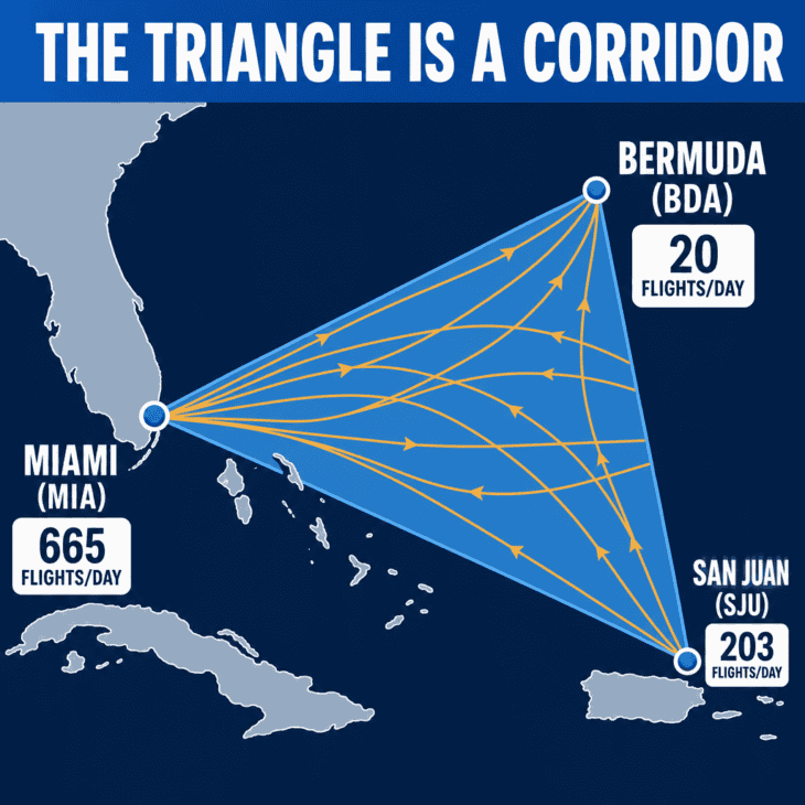
The Triangle has no official boundaries, but the version everyone draws puts its three points at Miami, Bermuda, and San Juan. Every one of those points is a commercial airport with scheduled service.
Miami International alone averages 665 flights a day to 224 destinations. San Juan’s Luis Munoz Marin International runs 203 flights a day, and L.F. Wade International in Bermuda adds another 20.
That is close to 900 daily departures and arrivals from the corner points by themselves, before counting a single overflight.
| Corner point | Airport | Flights per day | Destinations |
|---|---|---|---|
| Miami, Florida | Miami International (MIA) | 665 | 224 |
| San Juan, Puerto Rico | Luis Munoz Marin (SJU) | 203 | 75 |
| Hamilton, Bermuda | L.F. Wade International (BDA) | 20 | 25 |
The controlling agency tells the same story. Miami Center, the FAA facility that works most of this airspace, handled 2,643,111 aircraft operations in 2024, making it the second busiest en route center in the United States.
Its airspace covers roughly 22.5 million cubic miles of Florida, the Gulf, and the western Atlantic, and it hands traffic off to controllers in the Bahamas, Cuba, Haiti, the Dominican Republic, and the Turks and Caicos. There is no gap in the middle where aircraft are told to steer clear.
What the loss statistics actually say
The core claim behind the legend is that aircraft and ships vanish there at an abnormal rate. Every organization in a position to measure that has looked, and none of them found it.
NOAA’s position is blunt: there is no evidence that mysterious disappearances occur with any greater frequency in the Bermuda Triangle than in any other large, well-traveled area of the ocean. NOAA also notes that the US Board on Geographic Names does not recognize the Bermuda Triangle as an official name and keeps no file on the area.
The US Coast Guard, which runs search and rescue there, reached the same conclusion after reviewing many aircraft and vessel losses in the region: nothing indicated that the casualties resulted from anything other than physical causes, and no extraordinary factors were ever identified.
The insurance market votes with its money
Lloyd’s of London, which has been pricing marine risk since the 1680s, charges no premium surcharge for vessels transiting the Bermuda Triangle. A 2013 WWF study of global shipping-accident data ranked the world’s ten most dangerous stretches of water for shipping. The Bermuda Triangle did not appear on the list.
That last point matters more than any official statement. Insurers have every commercial incentive to find a genuinely dangerous region and charge for it. They looked, and there was nothing there to price.
The famous cases have unglamorous answers
The legend rests on a small set of incidents that get retold without their case files. Read the actual investigations and the pattern is depressingly ordinary: bad weather, bad navigation, mechanical failure, and open ocean deep enough to hide the wreckage.
December 1945
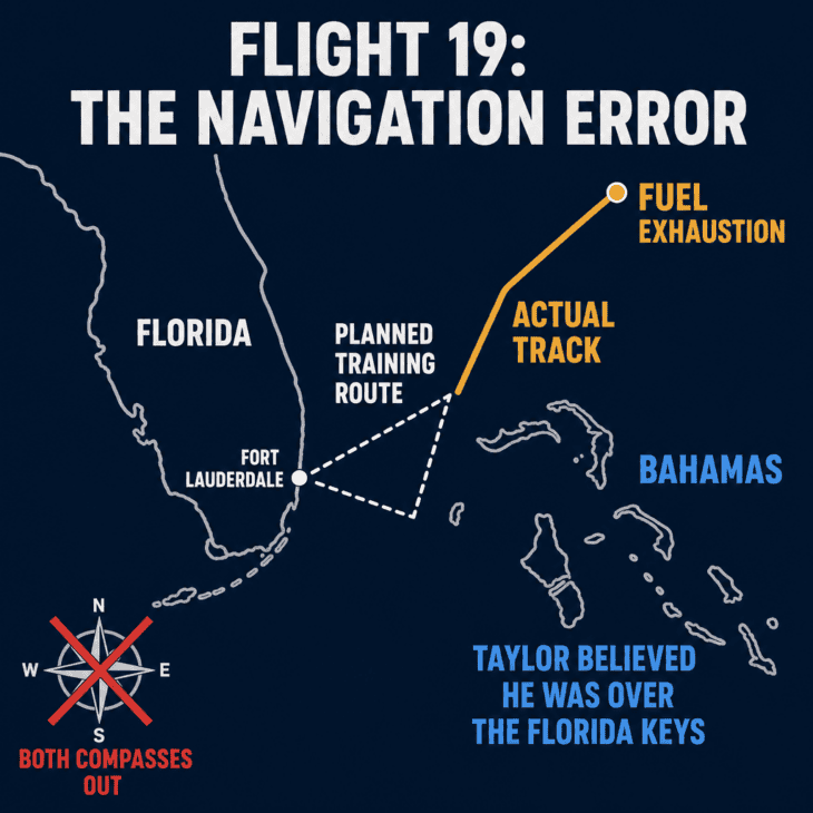
Flight 19. Five TBM Avengers on a training flight from Fort Lauderdale are lost with 14 men. Flight leader Lt. Charles Taylor radioed that both of his compasses were out; he appears to have mistaken the Bahamas for the Florida Keys and led the formation farther out to sea until the fuel ran out, into a deteriorating sea state after dark.
That same night
The search aircraft. A PBM Mariner flying boat launched to look for them and never returned, killing 13. At 21:15 the tanker SS Gaines Mills reported flames from an explosion leaping 100 feet (30 m) and burning for around ten minutes. Crews nicknamed the fuel-leak-prone Mariner the “flying gas tank.”
January 1948 and January 1949
Star Tiger and Star Ariel. Two British South American Airways Avro Tudor IVs disappear a year apart near Bermuda. Both formal inquiries found the crews experienced and the evidence nonexistent, and returned a verdict of cause unknown rather than anything stranger.
October 2015
SS El Faro. A cargo ship sails into Hurricane Joaquin near the Bahamas and sinks with all 33 aboard. Because the voyage data recorder was recovered, the NTSB could name a probable cause: the captain’s insufficient action to avoid the storm, outdated weather information, and a late decision to muster the crew.
The El Faro case is the useful one. It happened squarely inside the Triangle, in the modern era, and it was investigated to the last detail because the recorder was found on the seabed.
There was no mystery. There was a ship, a hurricane, and a series of human decisions. Every one of the older cases lacked that evidence, which is precisely why they stayed open, and open cases are the raw material of legends.
That gap between “unexplained” and “inexplicable” is where the whole genre lives. It is the same reason a handful of passenger planes that disappeared stay famous for decades while thousands of thoroughly documented accidents do not.
The myth: a compass anomaly that has since moved
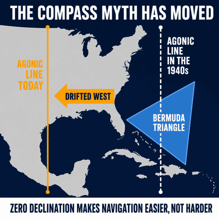
The most durable technical claim about the Triangle is that it is one of only two places on Earth where a magnetic compass points to true north rather than magnetic north, supposedly confusing navigators. That line sits in a lot of otherwise reputable sources, including NOAA’s own explainer, which has not been updated since 2010.
Why the compass argument fails twice
First, the agonic line where true and magnetic north align is not fixed. It has drifted west and now runs through the Gulf of Mexico and the central United States, not the Atlantic off Florida. Second, magnetic declination is a published, mapped, entirely routine correction that every navigator applies everywhere on Earth. A region with zero declination is the easiest place to navigate, not the hardest.
The Triangle does have real hazards, but they are the same ones any subtropical ocean has. It sits in the middle of the Atlantic hurricane belt, and it contains the Gulf Stream, a fast, warm current that spawns sudden violent weather and can carry floating wreckage far from a crash site within hours.
Airlines handle that the way they handle weather anywhere: forecasting, routing, and avoidance. It is worth understanding what happens when planes and hurricanes meet, because the storms are the genuine risk in that region and always have been.
The traffic mix matters too. Below the airline layer, this is heavy general aviation country: light single-engine aircraft island-hopping over water, often flown by pilots with modest instrument experience. That mix produces accidents in the Caribbean for the same reasons it produces them in Alaska or the Alps.
Where the legend actually came from
The phrase itself is younger than most people assume. Writer Vincent Gaddis coined “The Deadly Bermuda Triangle” for a February 1964 cover story in the pulp magazine Argosy, and Charles Berlitz’s bestselling 1974 book turned it into a global phenomenon.
The debunking arrived almost immediately. Librarian Larry Kusche spent years pulling the original newspaper reports, accident files, and Lloyd’s records for every incident on the list, and published his findings in 1975.
His conclusion was devastating and specific. Nearly every case had a mundane cause, or happened somewhere else entirely, or could not be shown to have happened at all. He called the Triangle a manufactured mystery, assembled from sloppy research and the occasional invented detail.
Sixty years of satellite tracking, ADS-B, and modern search technology have not produced a successor mystery. If anything, the Triangle’s reputation is a historical artifact of an era before aircraft broadcast their position continuously.
Compare it to the genuine reasons airlines do reshape routes over water. Aircraft really do avoid certain airspace, and there are real explanations for why so few flights cross the Gulf of Mexico and for how polar routes are flown. Those constraints are about diversion airports, fuel, and demand, not folklore.
So the next time a flight tracker shows your aircraft crossing that stretch of blue between Florida and Bermuda, the accurate reaction is not a shiver. It is that you are in one of the most-watched, most-flown, most-thoroughly-charted pieces of ocean airspace on the planet.
The Triangle’s real distinction was never that things disappeared there. It was that so much moves through it that, over eighty years, a handful of losses were bound to happen, and a few of them happened before anyone had the tools to explain why.
Sources and references used for research and fact-checking.
- NOAA National Ocean Service, What is the Bermuda Triangle?
- Naval History and Heritage Command, H-057-4: The Disappearance of Flight 19
- National Transportation Safety Board, Sinking of US Cargo Vessel SS El Faro, Atlantic Ocean, Northeast of Acklins and Crooked Island, Bahamas, October 1, 2015
- Wikipedia, Miami Air Route Traffic Control Center
- Encyclopaedia Britannica, Bermuda Triangle: Description, Location, Disappearances, Map, and Facts
- Prometheus Books (Larry Kusche), The Bermuda Triangle Mystery: Solved
Get the Newsletter
The latest aviation news and stories sent to your inbox.
About the Author
Tim is the owner and lead editor of AeroCorner since 2019, overseeing aviation content covering aircraft, airlines, airports, and the broader aviation industry. Through years of researching, writing, editing, and publishing aviation-focused content, he has developed extensive practical knowledge of commercial aviation and air travel. Based in Asia and a frequent traveler himself, Tim also brings firsthand passenger experience to AeroCorner’s coverage. Outside of publishing, he has also explored aviation firsthand through hands-on flight training in New Zealand.